
Photo Record
Images
Metadata
Title |
1855 Map of Elgin (9 of 9 Sections) |
Catalog Number |
1989.001.1039 |
Object Name |
Print, Photographic |
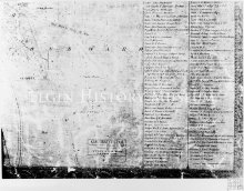
Description |
Section 9 of 1855 Map of Elgin (9 of 9 Sections). Map of Elgin, Kane Co. ILL, Surveyed Drawn and Published by Thomas Doran, 1855, Pop 3,500, Lith of Ed Mendel, 170 Lake St. Chicago. Right side of image contains long, double columned list of personal and business names. Left side of image shows lots owned by Bent, Dexter, Bowlin and others. |
Date |
1855 |
Photographer |
Elmer Gylleck |
Print size |
9.375 X 13.000 |
Imagefile |
010\19890011039.JPG |
Caption |
Map of Elgin 1855 |