
Photo Record
Images
Metadata
Title |
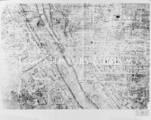
1855 Map of Elgin (5 of 9 Sections) |
Catalog Number |
1989.001.1035 |
Object Name |
Print, Photographic |
Description |
Section 5 of 1855 Map of Elgin (5 of 9 Sections). Map of Elgin, Kane Co. ILL, Surveyed Drawn and Published by Thomas Doran, 1855, Pop 3,500, Lith of Ed Mendel, 170 Lake St. Chicago. The Fox River runs through the center of this map section. The property lots are small and a great number of surnames are shown. Streets shown include Mountain, Mill, Ball, Broadway and Villa to the West of the river. To the East of the river Park, Prairie, Fulton, Chicago, Milwaukee, Division, Dexter, North, Race, Kimball, DuPage, Gifford and Railroad streets are among those seen. |
Date |
1855 |
Photographer |
Elmer Gylleck |
Print size |
9.250x 13.125 |
Imagefile |
010\19890011035.JPG |
Caption |
Map of Elgin 1855 |